


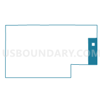
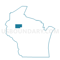
HAWKINS - T 1 Voting District, Rusk County, Wisconsin
About
Outline

Summary
| Unique Area Identifier | 696736 |
| Name | HAWKINS - T 1 Voting District |
| County | Rusk County |
| State | Wisconsin |
| Area (square miles) | 45.76 |
| Land Area (square miles) | 45.64 |
| Water Area (square miles) | 0.13 |
| % of Land Area | 99.72 |
| % of Water Area | 0.28 |
| Latitude of the Internal Point | 45.45645630 |
| Longtitude of the Internal Point | -90.74201290 |
Maps

Graphs
Select a template below for downloading or customizing gragh for HAWKINS - T 1 Voting District, Rusk County, Wisconsin


Neighbors
Neighoring Voting District (by Name) Neighboring Voting District on the Map
- GEORGETOWN - T 1 Voting District, Price County, WI
- Hawkins - V 1 Voting District, Rusk County, WI
- JUMP RIVER - T 1 Voting District, Taylor County, WI
- KENNAN - T 1 Voting District, Price County, WI
- LAWRENCE - T 1 Voting District, Rusk County, WI
- RICHLAND - T 1 Voting District, Rusk County, WI
- SOUTH FORK - T 1 Voting District, Rusk County, WI
- WESTBORO - T 1 Voting District, Taylor County, WI
Top 10 Neighboring County Subdivision (by Population) Neighboring County Subdivision on the Map
- Westboro town, Taylor County, WI (684)
- Jump River town, Taylor County, WI (375)
- Kennan town, Price County, WI (356)
- Lawrence town, Rusk County, WI (311)
- Hawkins village, Rusk County, WI (305)
- Richland town, Rusk County, WI (232)
- Georgetown town, Price County, WI (171)
- Hawkins town, Rusk County, WI (153)
- South Fork town, Rusk County, WI (120)
Top 10 Neighboring Place (by Population) Neighboring Place on the Map
Top 10 Neighboring Unified School District (by Population) Neighboring Unified School District on the Map
- Ladysmith-Hawkins School District, WI (6,020)
- Flambeau School District, WI (3,743)
- Gilman School District, WI (3,213)
- Rib Lake School District, WI (2,673)
Top 10 Neighboring State Legislative District Lower Chamber (by Population) Neighboring State Legislative District Lower Chamber on the Map
Top 10 Neighboring State Legislative District Upper Chamber (by Population) Neighboring State Legislative District Upper Chamber on the Map
Top 10 Neighboring 111th Congressional District (by Population) Neighboring 111th Congressional District on the Map
Top 10 Neighboring Census Tract (by Population) Neighboring Census Tract on the Map
- Census Tract 9601, Rusk County, WI (3,792)
- Census Tract 9707, Price County, WI (2,514)
- Census Tract 9602, Taylor County, WI (2,331)
- Census Tract 9704, Price County, WI (1,861)